Do You Know Who Owns the Point of Rocks Bridge?

Do you know who owns the Point of Rocks Bridge?

The answer may shock you.  It also raises potential questions about the competency of our elected officials, County Staff and the consultants who are leading the Route 15 process.  The letter below is courtesy of a submission to [email protected].  Please continue to share your feedback with us (and the Fix Route 15 Now community).

Fix Route 15 Now!

Follow us on Facebook


August 31, 2018

Loudoun County

Supervisor Geary Higgins

P.O. Box 7000

Mailstop #01

Leesburg, VA 20177-7000


Supervisor Higgins:

I am writing to you regarding certain facts and characterizations of the Point of Rocks Bridge as it pertains to the Route 15 Stakeholder Group that you oversee.  I recently learned the following about the Point of Rocks Bridge:

Ownership– The bridge is jointly owned by the Commonwealth of Virginia and the State of Maryland (“each an undivided one-half interest”).

Maintenance– The maintenance cost of the bridge is shared equally between the Commonwealth of Virginia and State of Maryland (“each shall pay one-half of the cost of repair, operation and maintenance”).

Tolls– Tolls are prohibited except for covering the initial acquisition cost of the bridge (“shall be free of tolls”).

Below is a text version of the 1929 agreement between the Commonwealth of Virginia and State of Maryland covering the acquisition, ownership, maintenance and tolls related to the Point of Rocks Bridge.  I have also attached the original agreement.

I have observed multiple Route 15 Stakeholder meetings, Board of Supervisor meetings and public hearings.  During these meetings and hearings, I continue to hear people (including one or more Supervisors) suggest putting a toll on the Virginia side of the bridge to discourage Marylanders from coming to Virginia.  I have also heard people say the bridge belongs to Maryland or that Maryland would do nothing with their bridge.  Did you know that all of these statements are false or misleading?  Did you, County Staff, or Kimley-Horn know who owns the bridge, bears the financial responsibility for maintaining the bridge or that there is a prohibition against tolls?  Did you find amusement in the fact that Stakeholder Committee members and others wasted time discussing these questions?  It would have been helpful if the record was set straight.

I expect that the facts outlined above regarding the Point of Rocks Bridge to be included in the Safety and Operations Study to be presented to the Board of Supervisors in September.

Below is the text from a 1929 Agreement between the Commonwealth of Virginia and State of Maryland to acquire and maintain the bridges at Point of Rocks and Brunswick, Maryland.

___________________________________________________________________________________________________________________

THIS AGREEMENT, made as of this 22nd, day of July 1929, by and between the COMMONWEALTH OF VIRGINIA, acting by and through the State Highway Commission, of the first part, hereinafter called “Commonwealth”, and the STATE of MARYLAND, acting by and through the State Roads Commission, of the second part, hereinafter called “State”, and the BOARD OF SUPERVISORS OF LOUDOUN COUNTY, Virginia, hereinafter called “County”, of the third part, the Commonwealth and County acting pursuant to authority vested by an Act of the General Assembly of Virginia of 1928, Chapter 516, page 1358, and the State pursuant to authority vested by Act of the General Assembly of Maryland of 1929, Chapter 542.

WITNESSETH:

The parties hereto do hereby covenant and agree as follows:

(1)  The Commonwealth and the State do hereby covenant and agree, each with the other, to purchase and acquire prior to December 31, 1929, the interstate highway bridge and approaches , over the Potomac River near Point of Rocks, Maryland, connecting Virginia State Highway Route Two (now known as Route 32), with the Maryland State Highway System, each to pay one-half of the purchase price thereof, the said purchase price not to exceed the sum of One Hundred Thousand ($100,000) Dollars, and each to pay one-half of all necessary expenses hereafter incurred in the purchase of the said property.  Title to said bridge and approaches shall be vested jointly in the Commonwealth of Virginia and State of Maryland, in each an undivided one-half interest.

(2)  The State and County do hereby covenant and agree, each with the other to purchase and acquire prior to December 31, 1929, the interstate highway bridge and approaches, over the Potomac River, at Brunswick, Maryland, connecting County highway Number Nine with the Maryland State Highway System, a price not to exceed $100,000, and payable as hereafter provided, and each to pay one-half of all necessary expenses hereinafter incurred in the purchase of said property. Title to said bridge and approaches shall be vested jointly in the State of Maryland and the Board of Supervisors of Loudoun County, in each an individual one-half interest.

(3)  The Commonwealth, State and County, covenant, and agree that pursuant to arrangements as to details of collection, accounting and disbursements to be made by the State Highway Commission and the State Roads Commission of Maryland, tolls shall be charged for use of each of said bridges and approaches at the same rate of toll in effect March 28, 1928, and that the tolls so collected shall be applied, after the payment of the costs of collection, on the purchase price of the bridge and approaches at Brunswick, Maryland, at a price not to exceed the sum of $100,000 and interest thereon, until such purchase price and interest thereon is fully paid, and that thereafter both of said bridges and approaches shall be free of tolls.

(4)  The Commonwealth and State covenant and agree, each with the other, that each shall pay one-half of the cost of repair, operation and maintenance of the bridge and approaches near Point of Rocks, Maryland, and that the details of repairs, operations and maintenance for each year shall be planned in advance by the State Highway Commission of Virginia and State Roads Commission of Maryland.

(5)  The State and the County covenant and agree, each with the other, that each shall pay one-half of the cost of repair, operation and maintenance of the bridge and approaches at Brunswick, Maryland, and that the details of repairs, operations and maintenance for each year shall be planned in advance by the County and the State Roads Commission of Maryland.

(6)  The Commonwealth, State and County, each covenants and agrees with the other that no effort will at any time be made by either of them, or any sub-division thereof, to levy, assess or collect any tax upon the interest or title of either of the others, or any political sub-division thereof, on either or said bridges and approaches.

IN WITHESS whereof the Commonwealth of Virginia has caused these present to be executed in its name and in its behalf by the State Highway Commission, the State of Maryland by its State Roads Commission and the County of Loudoun, Virginia, by its Board of Supervisors.

COMMONWEALTH OF VIRGINIA

By /signed/

State Highway Commission

STATE OF MARYLAND

By /signed/

State Roads Commission
Comments Off on Do You Know Who Owns the Point of Rocks Bridge?

Journey Through Hallowed Ground (JTHG) – Access, Influence & Money

Who is the Journey Through Hallowed Ground (JTHG)?

You may be wondering who is the Journey Through Hallowed Ground (JTHG) Partnership?  What is their purpose?  Who do they represent?  Does the JTHG care about congestion or safety?  Let’s take a look. The JTHG is a non-profit 501(c)(3) organization that was formed in 2005.

https://www.hallowedground.org

Their website describes the JTHG as:

“The Journey Through Hallowed Ground Partnership is a non-profit, four-state partnership dedicated to preserving our American heritage in the region running from Gettysburg, PA through Maryland and Harpers Ferry, WV to Jefferson’s Monticello in Albemarle County, VA.” “Congress named the Journey Through Hallowed Ground a National Heritage Area in 2008 – the nation’s 38th — and the Secretary of Transportation designated the main thoroughfare running through it a National Scenic Byway in 2009 – the nation’s 99th.” The National Scenic Byway encompasses what was once known as the Old Carolina Road, which now includes Routes US 15, VA231, VA20 and VA53.”

Below is a link to JTHG’s Tax Exemption submission to Loudoun County (including Federal filings, Articles of Incorporation, Bylaws, Financials, Statement of Justification and other supporting documents):

https://www.loudoun.gov/documentcenter/view/108787

Further, per JTHG’s Loudoun County Tax Exemption application (pg3 Item 12), JTHG represented that it is not “involved in carrying on propaganda, or otherwise attempting to influence legislation” emphasis added. Below is a link to the IRS (and excerpt) regarding the definition of lobbying as it pertains to non-profit 501 (c)(3) organizations:

https://www.irs.gov/charities-non-profits/lobbying

 “An organization will be regarded as attempting to influence legislation if it contacts, or urges the public to contact, members or employees of a legislative body for the purpose of proposing, supporting, or opposing legislation, or if the organization advocates the adoption or rejection of legislation.”

All of the children’s education programs, camps and tree planting activities appear to be a noble cause.  However, is road engineering and design part of JTHG’s mission?  Also, after reading the JTHG’s fundraising letter, cited later in this post below, ask yourself – Is the JTHG lobbying elected officials?

Route 15 Process

Let’s see how the JTHG is participating in the Route 15 process.

First, the JTHG is a member the Route 15 Stakeholder Committee.

Route 15 Stakeholder Committee Members:

https://www.loudoun.gov/DocumentCenter/View/129269

Route 15 Stakeholder Committee Charter:

https://www.loudoun.gov/ArchiveCenter/ViewFile/Item/7429

Second, the JTHG has been given unfettered access to our elected representative. In fact, Supervisor Geary Higgins went out of his way to invite the JTHG for their input to the “Route 15 Congestion Report” that was eventually presented to the Board of Supervisors on May 18, 2017.

Supervisor Geary Higgins email to JTHG Bill Sellers 11-18-16

Third, the JTHG was selected as one of only three “stakeholders” in the Route 15 Congestion Report dated May 18, 2017 (see Pages 31 & 32).  Note there were no citizen stakeholders included in the report.

https://lfportal.loudoun.gov/LFPortalinternet/0/doc/218963/Electronic.aspx

A copy of Section 7 Stakeholder Input Summary:

Stakeholder Input Summary 5-18-17

Fourth, the JTHG had nothing to offer in the report regarding Route 15’s congestion or safety.  The JTHG was only concerned about removing berms along Route 15 in front of the Big Springs community.  Below is an excerpt from the report:

JOURNEY THROUGH HALLOWED GROUND (JTHG)

Given the US Route 15 corridor designation as a national scenic byway, a meeting was held on December 13, 2016 with Bill Sellers, the President and CEO of the JTHG Partnership. The JTHG encouraged Loudoun County to utilize the design guidelines contained in their adopted Corridor Management Plan (available online at https://www.hallowedground.org/Partner-Resources/National-Scenic-Byway/Corridor- Management-Plan). Some of the key elements are:

  • Maintain the rural character of the roadway
  • Incorporate the Living Legacy Tree Planting Project
  • Follow the rural design elements in the Corridor Management Plan
  • Review screening and buffering conditions

JTHG acknowledged that the residential developments along the corridor have changed the roadway design with the addition of large mounds placed by the Big Springs homeowner’s association, shown in the photo below, and it no longer resumes the historic character intended for this scenic byway. Therefore, JTHG views this project as an opportunity to make improvements.

Fifth, the JTHG representatives to the Route 15 Stakeholder Committee rarely participate.  Why?  Could it be that they feel they have an inside track on influencing the outcome outside of the public process? They had every opportunity to participate, but now want to obstruct the process in the 11th hour by advocating for a solution that they know won’t work, won’t last, and is a big waste of money.

Sixth, the JTHG enjoys the benefit of Loudoun County promoting and displaying a link to its website on the County’s web page.

Fund Raising

The JTHG is now raising funds.  They seek to raise $20,000 to engage a designer to present an alternative plan.  The JTHG seeks to influence and persuade Loudoun County’s elected officials and decision makers. The JTHG’s fundraising letter “to persuade Loudoun County Officials”:

JTHG Letter 8-21-18

https://fixroute15now.com/wp-content/uploads/2018/09/JTHG-Letter-8-21-18.pdf

https://www.gofundme.com/route-15-coalition

Below is an excerpt from their Go Fund Me Page:

Route 15 Coalition – JTHG NSB

“Help save one of the most beautiful sections of the Journey Through Hallowed Ground National Scenic Byway, Route 15, in one of the most historically rich sections of the National Heritage Area, from a critical and urgent threat.

The Loudoun County government has been studying alternatives for the future of Route 15 from Leesburg to the Potomac River, and while they’ve said they want to preserve the historic and rural character of the road, new county documents show their intent is a four-lane divided expressway, which will attract more traffic.

Making this 2-lane rural highway a divided highway “with access limited to key intersections” will at least triple the road width, obliterating historic crossroads communities and historic structures, and sharply curtail access to the local small businesses, and heritage tourism on which the economic development of a National Heritage Area depends. It also threatens the viability of large working farms on either side of the roadway.

There is a better, cheaper, and more effective way to address current congestion and safety issues on the road—by using the award-winning model of the Route 50 Traffic Calming Project in Loudoun. We have engaged the designer of that successful project to provide an alternative design vision for Route 15—but we need your help to achieve it. We need to raise $20,000 to get this alternative in front of local and state officials. Can you help us save this irreplaceable part of United States history?”

Are the JTHG’s “persuasion activities” of “Loudoun County officials” prohibited by the IRS?

https://www.irs.gov/charities-non-profits/charitable-organizations/exemption-requirements-section-501c3-organizations

“The exempt purposes set forth in section 501(c)(3) are charitable, religious, educational, scientific, literary, testing for public safety, fostering national or international amateur sports competition, and preventing cruelty to children or animals.  The term charitable is used in its generally accepted legal sense and includes relief of the poor, the distressed, or the underprivileged; advancement of religion; advancement of education or science; erecting or maintaining public buildings, monuments, or works; lessening the burdens of government; lessening neighborhood tensions; eliminating prejudice and discrimination; defending human and civil rights secured by law; and combating community deterioration and juvenile delinquency.”

Ethics in Loudoun County

Supervisor Kristen Umstattd (Leesburg District) and co-chair of the Route 15 Stakeholder Committee is a trustee of the JTHG.

https://www.hallowedground.org/About-Us/Leadership-Board/Kristen-C.-Umstattd

Considering that the JTHG’s role has drastically changed from being a member of the Route 15 Stakeholder Committee to now working outside the process, this is a clear conflict of interest whether real or perceived.  Kristen Umstattd should remove herself as a Trustee of the JTHG.  Ethics do matter in Loudoun County. A copy of the Loudoun County’s Code of Ethics and Standards of Conduct for the Board of Supervisors can be found:

BOS Current Code of Ethics 2016


Asks of Loudoun County:

  1. Return the Route 15 process to the citizens, not special interest groups
  2. All Supervisors to publicly publish and provide a calendar of their meetings with the JTHG since January 1, 2016 (including who they met with)
  3. Supervisor Umstattd to step down as Trustee of the JTHG
  4. Loudoun County to remove the JTHG link on the Loudoun County web page
  5. The BOS direct the Loudoun County attorney to review the JTHG’s tax exempt status with the County
  6. The BOS abide by the Code of Ethics and Standards of Conduct signed on January 21, 2016
  7. Grant no special favors or privileges to any individual or entity based on any outside influence or personal relationships
  8. FIX ROUTE 15 NOW!!!
Comments Off on Journey Through Hallowed Ground (JTHG) – Access, Influence & Money

Day 4: We need a 30-year solution!

One key point that we at fixroute15now.com advocate is that the corridor needs a long-term solution. Given that many projects in the region are competing for the same project dollars, we must not waste our time and money on feel-good “solutions” that will not serve through this time period. We WON’T get a do-over. Since it will take the county at least 10 years to widen a 3.5 mile section of the Route 15 corridor, we must look at growth curves going out 40 years.

The lower corridor today handles 26,000 vehicles per day (vpd). Kimley-Horn’s US Route 15 Congestion Report, dated May 18,2017, uses a 1.5% forecasted growth rate for the lower-end of the corridor (Battlefield Parkway to Montresor Road).  See Section 6: Traffic Forecasts (pages 25-26) of the report: https://lfportal.loudoun.gov/LFPortalinternet/0/doc/218963/Electronic.aspx

This is a conservative estimate considering volumes have been increasing by 3% per year for the last 5 years and spiked at 10% growth during 2017 – the last year for which records are available. We’ll say for the sake of argument that actual annual growth for the next 40 years will average somewhere between those two numbers. The chart below shows what that volume increase for the Lower Corridor will look like at different rates of growth:

What this chart tells us is that at even the most conservative growth rate estimate, 47,000 vehicles (predominately North-South traffic) will travel the Route 15 Lower Corridor on a daily basis at the end of the project’s lifespan (Phase I).

As for the Northern half of the corridor, Kimley-Horn will publish their projections in the next Safety & Operations Study, anticipated to be released in September. While we’re waiting for them, let’s use the same rates of growth from the first chart on the current volume of 21,000 vpd at the Point Of Rocks Bridge:

Keep in mind the following previously established maximum capacities:

  • Single lane roundabouts – 25,000 vehicles per day
  • Multi-lane roundabouts – 45,000 vehicles per day
  • 2-lane road – 18,000 vehicles per day
  • 4-lane road – 37,000 vehicles per day

 From this information, we can reasonably conclude several things:

  • Single-lane roundabouts will fail the Lower Corridor NOW even under CURRENT volumes.
  • Single-lane roundabouts will fail the Northern Corridor by the time they are completed.
  • Multi-lane roundabouts will fail the Lower Corridor within the project lifespan.
  • Multi-lane roundabouts will fail the Northern Corridor within the project lifespan under all but the most conservative growth estimates.
  • The entire corridor will fail without widening to 4-lanes and the Lower Corridor could eventually need more than that. Let’s hope that by 2057 there is a new Potomac crossing bridge in the works to take the stress off of Route 15.

These facts and capacities are NOT in dispute. Even one of the special interest groups’ website acknowledges the ~25,000 vpd capacity of single lane roundabouts: https://web.archive.org/web/20050207120921/http://catoctincoalition.com:80/FAQs.html

Yet, they still advocate for such a solution for the corridor even though they know it will fail. Why? Well, the main point of argument that they make is that widening the road will mean that more vehicles will use it, more development will happen, and more people will move in. Doesn’t this sound a whole lot like no-growth land use policies disguised as traffic engineering?

The fact of the matter, and what the special interests do not want to acknowledge, is that growth in this region is inevitable and currently that growth is happening in places we in Virginia have no control over – namely Frederick County, MD.

Now, let’s talk a bit about cost. What is the cost of a traffic signal vs. a roundabout?  Per Mr. Joseph Kroboth, Director of the Loudoun County Department of Transportation and Capital Infrastructure (DTCI), he indicated that the cost of a traffic signal is approximately $750,000 to $900,000 versus a single-lane roundabout that starts at $8,000,000.  Are we seriously going to spend $25,000,000 to $50,000,000 on the multiple single-lane roundabouts that the special interests advocate to install along the Route 15 corridor even though they would all be obsolete upon completion due to projected traffic volumes?  Do we want to spend significantly more than $50,000,000 for a corridor of double-lane roundabouts, which will ultimately fail within 30 years and need to be ripped up and replaced with lights?

Why are we even considering wasting the County taxpayers and Region’s money on solutions that will fail? Again, the answer seems to be because the special interests would rather do that than allow for even the potential of additional growth in the area. They still think they live in the middle of nowhere and don’t want anything to change.

Fix Route 15 Now!

Comments Off on Day 4: We need a 30-year solution!

Day 3: New Jersey Suburban and Rural Growth – The Fate of Traffic Circles

The state of New Jersey, the Garden State, was once the garden spot to slightly more than 100 traffic circles at one point.  It was an idea that had originally served its purpose well – way back in the 1920s! However, starting around the 1970s, New Jersey began phasing this type of road design out as populations grew. In fact, there are only a few traffic circles left today. The primary reason for their elimination was that the increased number of drivers on the roads resulted in traffic circles being more likely to hinder traffic flow than ameliorate traffic congestion. Moreover, the increased number of vehicles and faster traffic speeds made traffic circles even more dangerous and accidents more frequent.

So one has to ask themselves, why are the special interest groups advocating for roundabouts rather than widening on Route 15 North, when they know that those roundabouts pose significant safety challenges to our families AND STILL fail to address traffic congestion given the massive North-South traffic flow on Route 15?

The answer is quite simple – roundabouts are now being heralded as a “traffic calming” mechanism.  Traffic calming is the code word for further reducing capacity by lowering the speed limit to approximately 10-15 MPH in the roundabout on a road that has vehicle volumes at almost 300% of what Route 15 was engineered to handle back in the late 1940s to early 1950s. As we’ve shown the last two days, roundabouts by themselves are woefully inadequate to address the massive North-South traffic flow on Route 15.

In summary, the special interest groups’ mantra has been oft repeated as one for improving safety, access and flow. However, their advocacy for single lane, “traffic calming” roundabouts with no widening really results in increasing congestion since this type of roundabout cannot accommodate more than 25,000 vehicles per day – a number that is below the current day 26,000 vehicles per day in the 3.5 mile stretch of Route 15 between Battlefield Parkway and Montresor Road. It is a safe bet that in 10 years when this project is completed, the daily number of vehicles will have increased substantially above the current day volume, further rendering the design obsolete before it is even constructed. Whether a traffic circle or roundabout, the daily number of North-South vehicles will make these designs obsolete.

So again, one has to ask themselves, why are the special interest groups advocating for roundabouts that pose significant safety challenges to our families and school children with increased risks of accidents AND STILL fail to address traffic congestion?

The answer is pretty clear; “People Die On Roads, Driving is a Dangerous Business!”

Remember, the data and science do not support roundabouts on Route 15 – don’t be fooled by the hype!  It’s nothing more than “no-growth” hysteria masquerading around as science and transportation engineering.

Comments Off on Day 3: New Jersey Suburban and Rural Growth – The Fate of Traffic Circles

Day 2: Gilberts Corner and Traffic Calming

Gilberts Corner is the intersection of Route 15 and Route 50.  For many years this was a signalized intersection until it was redesigned with three roundabouts in 2008.  

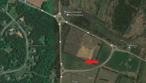
One of the common refrains from the special interest groups is: The roundabouts at Gilberts Corner worked so let’s build them on Route 15 instead of widening. Below is a satellite picture of the Gilberts Corner intersection.

First some volume numbers for the Gilberts Corner intersection:

Route 15 – 14,000 Annual Average Weekday Traffic (AAWDT)

Route 50 – 18,000 Annual Average Weekday Traffic (AAWDT)

Source: http://www.virginiadot.org/info/2017_traffic_data_by_jurisdiction.asp

Satellite picture of Gilbert's Corner

Both Route 50 and Route 15 at Gilberts Corner are at or within the 18,000 vehicle per day capacity constraint for a 2 lane road. There are three key reasons why the three roundabouts work (for now) at Gilberts Corner:

1.      Balanced Directional Volume – The intersection has near equal volume coming from all directions (unlike Route 15 North). Having balanced directional volume is a key part of Mr. Spack’s research on successful roundabouts that was cited yesterday.

2.      Three Roundabout Design – The three roundabout design allows vehicles to be dispersed and follow the path of least resistance.  For example, the roundabout at Howsers Branch Drive allows some Westbound Route 50 volume to avoid the main roundabout and head south on Route 15. See the red arrow above. This three roundabout design is neither an option on Route 15 North nor has it been proposed by the County. It is simply a non-starter.

3.      Usage of 4 Lanes of Travel – The AAWDT traffic count of 32,000 for the combined intersection is NOT handled by a 2 lane road with a roundabout as the special interests would have you believe. There are 2 lanes on Route 15 as well as 2 lanes on Route 50. If we include the Howsers Branch cutoff, there are 6 lanes in play at this intersection.

The three roundabout situation at Gilberts Corner, while effective for now, is in no way a comparative situation to what exists on Route 15 North of Leesburg.

The second argument that the special interest groups make is that traffic calming measures similar to those created on Route 50 through Aldie and further westward, when combined with roundabouts, will completely solve the problems on Route 15 North. The problem with their argument and what makes it irrational is simply this – The traffic volume on Route 50 through the Aldie/Middleburg area is less than 10,000 AAWDT. Route 15 North handles 250% more volume!

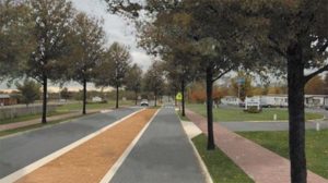
Even though we have shown traffic calming “solutions” to be completely irrelevant to Route 15 North, we do want to make sure everyone understands what the special interest groups mean when they tout this supposed solution. Traffic calming as the special interest groups envision for Route 15 North includes not only single lane roundabouts (which we’ve already shown will not handle the current traffic volume) but also trees on both sides of the road as well as in a median, even slower speed limits, limited sight lines, and maybe, if they are forced to add them, small grass shoulders rather than paved ones. 

Here is a link to an archive of the website of one group that advocates against widening (site is no longer active): 

https://web.archive.org/web/20050124173205/http://catoctincoalition.com:80/.

Notice the picture at the bottom of their page which shows how they envision Route 15 North. It’s pictured here as well.

Although a pretty scene, does this narrow 2 lane road design with trees inches from the edge represent what you think Route 15 should look like? Do you think this design has even a remote chance of providing the capacity increase that we need? Is a tree lined road with no shoulders going to improve safety? The decision is yours.

Stay tuned as we continue our series of informative articles.

Fix Route 15 Now!

Comments Off on Day 2: Gilberts Corner and Traffic Calming

Day 1: Roundabout Facts and Route 15 Volume

Roundabouts are a hot topic when it comes to the discussion of Route 15 improvements. Some groups would have you believe that just installing a roundabout at White’s Ferry Road would solve all the problems of the Route 15 corridor. They will also put forward plans that would turn Route 15 from Leesburg to the Point of Rocks Bridge into a series of roundabouts while placing obstacles, trees, and other impediments in places that would force vehicles to slow down in order to navigate through the corridor and avoid running into something. This is also known as “traffic calming”. We will address these two items separately.

First, some background. We at fixroute15now.com are a data driven, fact-based group and we will acknowledge the road engineering science of why some roundabouts work at certain intersections. There are real-world benefits to well-constructed roundabouts in the right locations. The challenge faced by many looking for a non-biased view of where and when roundabouts work is that most, if not all, readily available sources are either 100% for or against roundabouts. The vast majority of studies are also based on lower capacity single lane roundabouts rather than the higher capacity, multi-lane examples.

We did manage to find Mr. Mike Spack, PT, PTOE. He is a traffic engineer with many years of experience and a supporter of roundabouts. You can read his bio here: http://www.mikeontraffic.com/about/. His website, mikeontraffic.com, is a great source for balanced information regarding the use of roundabouts. http://www.mikeontraffic.com/why-build-roundabouts/ explains in detail the approach to building as well as positives and negatives of roundabouts. He mentions (our emphasis highlighted):

Research suggests a single lane roundabout can accommodate up to 25,000 vehicles per day. A multi-lane roundabout with two entry lanes can accommodate up to 45,000 vehicles per day. Like other traffic engineering tools, a roundabout works better with certain characteristics. The ideal conditions for a roundabout are:

  • Balanced traffic flow between all four legs. An unbalanced intersection with 90 percent of the volume on the major street may not see the same benefits as other more balanced locations.
  • High left turn movements. Left turns, and U-turns, are accommodated extremely well by a roundabout.
  • High crash history. Roundabouts can help reduce the severity of crashes and sometimes the overall number of crashes.
  • Complex geometry. A roundabout can often accommodate more than four legs and/or skewed intersections better than stop signs or a traffic signal.”

On this same page he also lists the major drawbacks of roundabouts:

There are no silver bullets in transportation planning and engineering.  Roundabouts are a better choice than traffic signals at most locations, however there are a few limitations the design engineer should consider:

  • There may not be enough room to build the roundabout.
  • A corridor with a heavy commuter pattern (most vehicles going one direction in the morning and then returning in the evening) can sometimes provide less delay with coordinated traffic signals.
  • The overall distance pedestrians need to walk is often longer around a roundabout than a traffic signal controlled intersection.
  • More difficult for visually-impaired pedestrians to cross compared to traffic signals.
  • Roundabouts are static. Traffic signals can adapt to significantly different traffic patterns, like traffic letting out after a concert or football game at a stadium.
  • Multi-lane roundabouts can be difficult in terms of design and operation. The delay and safety experience at a multi-lane roundabout is sensitive to small geometric characteristics.”

Ask yourself this question – does Route 15 have balanced flow from all sides or does it have a “heavy commuting pattern” with the vast majority of volume coming from one direction?

Now on to the numbers. According to VDOT’s 2017 volume numbers found here: http://www.virginiadot.org/info/2017_traffic_data_by_jurisdiction.asp, the traffic count on Route 15 around the Point of Rocks Bridge is 21,000 vehicles per day and 26,000 per day around White’s Ferry Road. Both are increasing every year. Mr. Spack provides the guidelines that a single lane roundabout can handle up to 25,000 vehicles. That is less than the current volume on Route 15 at White’s Ferry and will be less than the volume on the rest of the corridor by the time any project is completed. This means that large multi-lane roundabouts with a 45,000 vehicle capacity would be required at all intersections, if implemented.

Separate from roundabouts, He also mentions on another page: http://www.mikeontraffic.com/numbers-every-traffic-engineer-should-know/  the acceptable planning levels of daily capacity for several types of roads themselves. The two most pertinent ones are:

  • 2 lane (w/ left turn lanes):  18,300 vehicles per day
  • 4 lane (w/ left turn lanes):  36,800 vehicles per day

These numbers tell us that regardless of what type of intersections are installed between Leesburg and the Point of Rocks Bridge (i.e. traffic light or roundabout), expansion to 4 lanes is going to be required for the entire corridor in order to handle current volume.

We have also found this statistical analysis which draws the conclusion through regression analysis that the planning capacity of roundabouts is almost always overstated compared to actual results. https://www.sciencedirect.com/science/article/pii/S2095756416300563. One of the main challenges with roundabouts, and multi-lane roundabouts in particular is that driver behavior ultimately determines capacity and safety. One example of a problem situation lies just a few miles north of us. 

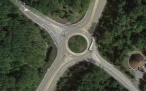
Point of Rocks Roundabout

The Google Maps satellite shows the roundabout on Route 15 in Maryland near the Point of Rocks Bridge. This is a multi-lane roundabout that the special interest groups love to point to as a success story.  This roundabout has approximately 21,000 vehicle trips per day.  Notice the semi-truck having to cross into the other lane in order to make the turn. Is this safe? 

So, with all of this data in mind, what we have here is an idea proposed by the special interest groups – turn the Route 15 corridor into a series of roundabouts – that, at best:

  • still requires 4 lanes to handle the volume;
  • will not work based on the pattern of heavy north/south volume;
  • functions LESS efficiently than coordinated traffic lights; and
  • creates potential safety issues when semi-trucks and other large vehicles must cross multiple lanes at once in order to navigate through the roundabout.

The special interest groups also maintain, despite the volume numbers proving otherwise, that single lane roundabouts AND traffic calming measures throughout the corridor will keep traffic moving. This is simply a false narrative and they need to be called out on it.

Please visit us again tomorrow when we will explain how the Route 50 roundabouts and traffic calming measures around Gilbert’s Corner and westward are not representative of the situation on Route 15.

Fix Route 15 Now!

Comments Off on Day 1: Roundabout Facts and Route 15 Volume

Why Will it Take 10 Years to Widen 3.5 Miles of Route 15?

Yes, 10 years! There is no sense of urgency by Supervisor Higgins or County Staff.

This timeline to complete the first Phase of Route 15 improvements is unacceptable, especially when the Right of Way (ROW) already exists to do so.

Loudoun County secured $54M of funding from the Northern Virginia Transportation Authority (NVTA) on June 14, 2018 to widen approximately 3.5 miles of Route 15 (from Battlefield Parkway to a point before, at or after Montresor Road).

Please see the FY 2018-2023 Six Year Program of the NVTA at the link below:

FY2018-2023-SYP-Project-List-Adopted-6.14.18-web-version.pdf

Combined with $26M of County funds, the total funding for the Phase I of the project will be $80M.

Sixty days later, and there is no action. To better understand the problem and lack of urgency below are some points to better understand why this project will take 10 years to complete:

  • The funding is secured, but the project has not started
  • The final concept design has not been presented to the Board of Supervisors (September 2018?)
  • The County was given control of the project by VDOT in December of 2017
  • No detailed project plan with activities, deliverables, accountable person(s) and dates exist
  • There are no County staff member(s) that are dedicated to this project on a full time basis
  • Special interests continue to demand further delays

All we hear from Supervisor Higgins is that everyone is “working hard”. There is a difference between “working hard” and “results”. County Staff and Geary Higgins have had close to a year to figure out how to accelerate the project.

Demand that Supervisors Geary Higgins, Kristen Umstattd and Phyllis Randall:

  1. Immediately start the project with the $3.5M that has been available since July 1, 2018 with legislative action at the September 20, 2018 Board meeting to form a dedicated project management team to accelerate the Route 15 project! This project will not start until Supervisors Higgins and Umstattd introduce this ACTION (which should have happened at the July 3, 2018 Board of Supervisors Meeting)!
  2. Request that this project be completed in the normal 3-year time-frame by streamlining the section 106 federal and state agency project review. Further, this process should happen in parallel with the engineering and design phase.
  3. Stand up to the special interest groups who are putting up barriers and delaying the design and construction of the Route 15 widening. We need safe roads for our families!

Write to:

Catoctin District Supervisor
Geary Higgins
[email protected]

Leesburg District Supervisor
Kristen Umstattd
[email protected]

Loudoun County Board of Supervisors Chair
Phyllis J. Randall
[email protected]

Fix Route 15 Now!

Comments Off on Why Will it Take 10 Years to Widen 3.5 Miles of Route 15?

Route 15 – Weekday Vehicle Trips Grew by 10.5% at the Point of Rocks Bridge in 2017!

The 2017 Virginia Department of Transportation (VDOT) data for Loudoun County is in:

http://www.virginiadot.org/…/2017_traffic_data_by_jurisdict…

The Annual Average Weekday Traffic (AAWDT) for the Virginia side of the Point of Rocks Bridge in 2017 was 21,000. Weekday vehicle trips grew by 10.5% (i.e. 2,000 vehicle trips) in 2017. Weekday vehicle trips for the last five years are as follows:

AAWDT (VDOT Link ID 090018 – Lucketts Road to the Maryland State Line)

2017 21,000
2016 19,000
2015 19,000
2014 18,000
2012 18,000

Note, AAWDT for the lower part of the corridor in 2017 was 26,000 weekday vehicle trips.

Vehicle growth continues on Route 15. There are no shoulders or widening proposed north of the Village of Lucketts. There is neither a timeline nor funding for the concept designs that are proposed north of Montresor Road. We will have to wait 10 years before we have four lanes from Battlefield Parkway to (or beyond) Montresor Road (only 3.5 miles). Imagine what the weekday vehicle trips will be in 10 years.

Fix Route 15 Now!

Comments Off on Route 15 – Weekday Vehicle Trips Grew by 10.5% at the Point of Rocks Bridge in 2017!

“People Die on Roads…Driving is a Dangerous Business”

On February 4, 2018 the Board of Supervisors held a public hearing regarding an amendment to the County’s Transportation Plan which would allow Route 15 to be expanded from a two lane road to a four lane road up to Montresor Road.  Many speakers took the time to make their opinions known to the Board of Supervisors.  Although a large majority of those present were in favor of the motion, which was unanimously approved by the Board of Supervisors, the most memorable moment of the night was during the Board comments, when Chairperson Randall took the unusual step of admonishing a speaker for her crass dismissal of the need for safety improvements on 15 by stating “people die on roads….driving is a dangerous business”.
This speaker truly believes that Route 15 is fine the way it is and nothing substantial should be done to fix the safety and congestion issues that we all face on a daily basis.
Please watch the attached video and decide for yourself if these comments represent you and your family.  If not, follow us on Facebook and Twitter, check out our website, and most importantly, contact your elected representatives to let them know that you demand immediate action to fix Route 15 now!

Comments Off on “People Die on Roads…Driving is a Dangerous Business”

Road Collapse on Stumptown Rd

This will definitely affect traffic in our area. We know many people use Stumptown Rd as a cut-through to avoid the crippling traffic on Route 15. Hopefully this doesn’t take as long to fix as its taking to address Route 15. Visit our “Get Involved” page to learn how to push our elected officials to make real changes in this corridor.

Officials investigating a bridge collapse in Loudoun County, as heavy storms throughout the area led to damage and flooding, as well as road closures throughout the area.


Comments Off on Road Collapse on Stumptown Rd

End of content

No more pages to load